| Version 10 (modified by , 3 years ago) ( diff ) |
|---|
Mini project 2022: Redesigning a map display status bar combo box into a new settings dialog
| Title: | Redesigning a map display status bar combo box into a new settings dialog |
| Student Name: | Linda Kladivova |
| Organization: | OSGeo - Open Source Geospatial Foundation |
| Mentor Name: | Anna Petrasova, Martin Landa, Vaclav Petras |
| GitHub Repository: | view repository |
| Budget: | 1000 € (via GRASS GIS Student Grants) |
Abstract
The project builds on the work started within the GSoC 2021 project called First steps towards the GRASS GIS Single-Window GUI. Within this coding period, a simple prototype of Single-Window GUI was proposed and partly implemented. It looks good at first glance from screenshots, however, there are many shortcomings and missing features that need to be removed/implemented to provide the Single-Window GUI layout as an optional mode in version 8.2.0.
Goal
The core part of the work will be devoted to the reorganization of the map display status bar. At the moment, the status bar at the bottom of the map display window consists of a text section, a combo box, a mask and a check box. For the Single-Window GUI, the number of widgets must be reduced so that the check box on the right side of the status bar is not shrunk. The solution is to cancel the combo box occupying too much space and implement a new settings dialog accessible from the top map display toolbar. So, the goal of the project is to create the fully functional testable Single-Window GUI mode which addresses the map display window settings through a new dialog.
A nice description of how it could look like is here: https://github.com/OSGeo/grass/issues/2017 .
Timeline
Time Period | Milestones | |
|---|---|---|
Tasks | Status | |
January 3 - January 9 | New Map Display settings dialog
|
|
January 10 - January 17 | Mask widget
|
|
June 17 - June 23 | Use defined projection checkbox
|
|
January 24 - January 30 | Projection settings
|
|
January 31 - February 6 | Customize statusbar from Map Display settings
|
|
February 7 - February 13 | Customize statusbar from Map Display settings
|
|
February 14 - February 20 | Merge Coordinates and Go To
|
|
February 21 - February 27 | EPSG text widget
|
|
Weekly reports
Week 1
1) What did I complete this week?
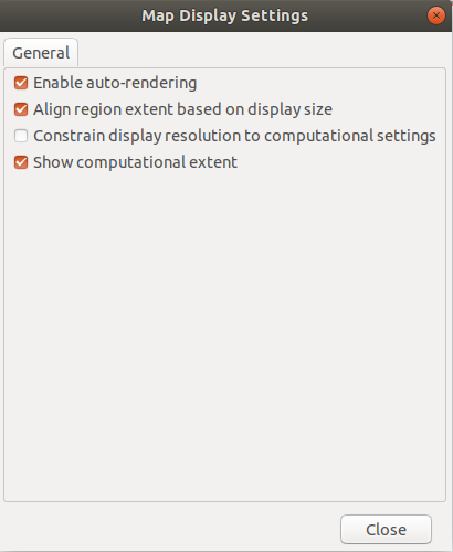
This week I worked on the new Map Display settings dialog which is accessible from the Map Display toolbar. I created a separate file for this purpose and proceed to move checkboxes from the Map Display status bar there - Render, AlignExtent, Resolution, and ShowRegion. The Render checkbox is also still accessible through the status bar, however other checkboxes were removed from the status bar combo box and are further available only from Map Display settings, for more info please see https://github.com/OSGeo/grass/pull/2031. Furthermore, I and Tomas Zigo managed to fix the closing event for the Map Notebook tab in the Single-Window GUI (see https://github.com/OSGeo/grass/pull/2072).
2) What am I going to achieve for next week?
Now it's time to move more complicated items from the status bar combo box. First I am gonna start to work on the Mask which will be newly placed to the main window status bar. It seems like a more complicated task.
3) Is there any blocking issue?
No, it isn't.
Week 2
1) What did I complete this week?
This week I have worked on moving the Mask widget to the main status bar (https://github.com/OSGeo/grass/pull/2089). It has shown to be quite a complicated task because we need to change the way of how the Mask in status bar is updated. In addition, I have opened the PR on moving the "Use defined projection" checkbox to our new Map Display settings dialog (https://github.com/OSGeo/grass/pull/2087).
2) What am I going to achieve for next week?
I am gonna finish the above-mentioned PRs. There is still quite lots of work and thinking - mainly on Mask.
3) Is there any blocking issue?
No, it isn't. Just regarding the rest of the week :-) - I am leaving for the weekend skiing holiday today so I will start working again on Monday.
Attachments (4)
-
mapdisplay_settings.png
(23.1 KB
) - added by 3 years ago.
Map Display Settings dialog after https://github.com/OSGeo/grass/pull/2031
-
general_settings.png
(333.8 KB
) - added by 3 years ago.
General page of Map Display Settings dialog
-
radiobox.png
(337.2 KB
) - added by 3 years ago.
Radiobox in Map Display settings for statusbar customization
-
multigui.PNG
(193.9 KB
) - added by 3 years ago.
Radiobox in Map Display settings for statusbar customization (Multi-Window GUI)
Download all attachments as: .zip

