| Version 3 (modified by , 18 years ago) ( diff ) |
|---|
MapGuide RFC 8 - PHP pages for describing a feature source
This page contains an change request (RFC) for the MapGuide Open Source project. More MapGuide RFCs can be found on the RFCs page.
Status
| RFC Template Version | 1.0 |
| Submission Date | unknown |
| Last Modified | jasonbirch Timestamp |
| Author | Rex Szeto, Tom Fukushima |
| RFC Status | adopted |
| Implementation Status | completed |
| Proposed Milestone | 1.2 |
| Assigned PSC guide(s) | unknown |
| Voting History | Dec 19, 2006 |
| +1 | Tom, Jason, Bruce, Andy, Haris, Paul, Bob |
| +0 | |
| -0 | |
| -1 |
Overview
Add some PHP pages that can be used to get the following information about a feature source:
- the set of schemas, classes, and properties
- the data in a class, shown in a table
- the feature data in a class shown graphically
Motivation
When using the feature source editors in Studio and Web Studio(?), it is not possible to get an idea of what is defined by the feature source. For example, it would be good to know what schemas, feature classes and properties are defined. Furthermore, it would also be nice to be able to see previews of the data in both tabular and graphical form. The proposed web pages provide this functionality, and could be integrated into a WebBrowser control in Studio or as part of the web page in Web Studio.
Proposed Solution
The proposal is to add some PHP pages to the MapGuide Open Source web tier that will, given a resource ID, display the desired information in a set of web pages. The scripts will be located in a different directory at the same level as the MapAdmin/MapAgent.
XSLT will be used to format the XML schema descriptions to HTML.
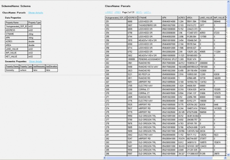
Tables will be used to show sample data from a selected feature class. It lists all the data properties as well as geometric properties for one or multiple classes/schemas. The user can specify which schema or class to view individually or choose to view all. Within each data property, the name and the type of the property is given. The identity property is marked with an asterisk beside the name. If the property is of a string type and there is a maximum length restriction, the value would be displayed. The user is able to view more details on a specific class by selecting “show details”. A table is then displayed with all the data values for the chosen class. This table has a maximum number of entries defined to prevent poor performance caused by loading a large set of data. The user is able to navigate through different pages to view all the information.
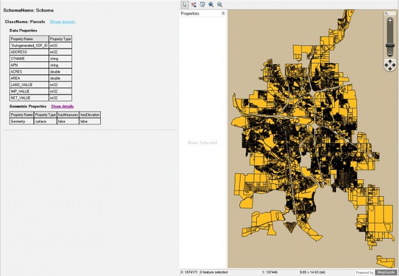
For each geometric property, the name, type, measures and elevation is given. The user is able to select “show details” to view the geometric property on a map. If the number of features in a feature source goes over a maximum value, a confirmation box would pop up, warning the user and ask if they would like to continue to show the map. If the user cancels, no display is shown. If the user chooses to continue, a graphical display will be shown in the map. The default background color will be beige and the feature colors will be orange for a surface geometry, blue for a line geometry, and red for a point geometry. The commands given in the map are: zoom in, zoom out, zoom rectangle, pan, and select.
Screenshot of data display window

|
Screenshot of geometry display window

|
Implications
This does not affect backwards compatibility.
We can leave these pages undocumented until there is a need to make them generally available.
There will be no checks or protections in place to prevent a user from doing a graphical preview on a huge dataset.
Test Plan
Create requests for these pages against a test feature source and make sure that the responses correctly match baseline data.
Funding/Resources
Autodesk
Attachments (2)
-
Data_Display.jpg
(173.9 KB
) - added by 18 years ago.
Screenshot of the data display window
-
Geom_Display.jpg
(130.4 KB
) - added by 18 years ago.
Screenshot of the geometry display window
Download all attachments as: .zip
